This article is the second part of the St. Williams/Turkey Point tour with the Turkey Point story
The first part the St. Williams Conservation Reserve (Nursery Tract) is found in Forestory Journal 2023 Vol. 14, Issue 2, pp. 25-39
Friday June 9, 2023
The St. Williams Forest Station was established in 1908 to grow tree seedlings for reforestation purposes and to stop the encroaching blow sands by growing permanent forests. The Turkey Point Forest Station was started in 1927 to grow permanent forest cover on the Charlotteville blow sands. Turkey Point Provincial Park was established in 1958 from the eastern part of the Turkey Point Station. Backus Woods is a spectacular older-growth forest, one of the best remaining examples of Carolinian forest in Canada.
Organizers:
Terry Schwan, R.P.F. (Ret.)
Adam Biddle, Supervisor, Forestry, Parks Operations Division, Norfolk County
Audrey Heagy, Project Coordinator St. Williams Conservation Reserve Community Council
Dolf Wynia St. Williams Forestry Station Superintendent 1983 to 1990
Other Contributions to this program include, Jeff Pickersgill, Superintendent, Turkey Point Provincial Park, Altah Arain, McMaster University, Dave Morris, MNRF and Ken Elliott, R.P.F.
This tour is hosted by the Forest History Society of Ontario and made possible by the generous support of our sponsor, Norfolk County.

Agenda Turkey Point only
9:15 Meet at Turkey Point parking area.
12:30 Turkey Point Provincial Park Lunch at picnic shelter
- H. White plaque and Arboretum
- Presentation by on Turkey Point Provincial Park by Jeff Pickersgill, Park Superintendent and tour of some park features.
14:00 Turkey Point Tract
- Picetum
- Variable Density trial.
- Black oak woodlands restoration. Walk in to area of black oak and on to the tower
- Carbon flux tower.
15:30 Back to Parking
Route Map
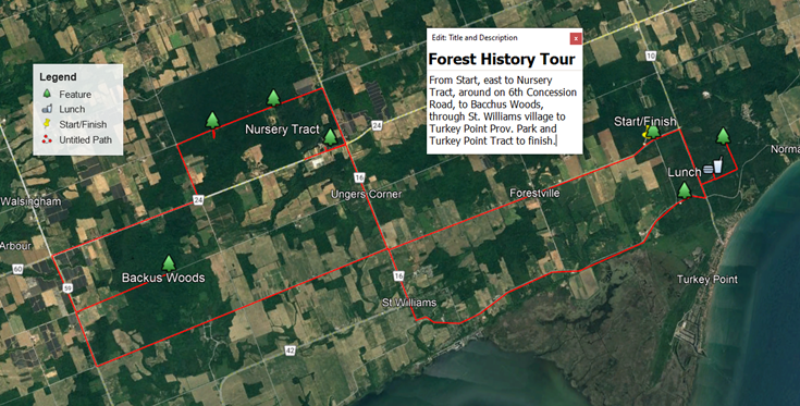
Turkey Point
Historical park and forest station to be established at Turkey Point in the Normandale plains.
E. J. Zavitz, December 15, 1927
It will be of interest to the people of Norfolk County to learn that the province of Ontario has secured about 1,500 acres of the sand lands near Turkey Point, commonly known as the Normandale Plains, which includes the historic townsite of Charlotte Villa laid out by Governor Simcoe in 1798. Turkey Point is rich in historical memories, and it may be of interest to give a brief sketch of its place in the early history of upper Canada.
The earliest record we have of this locality is in the journals of the Sulpician priest, Father Galinée who spent the winter of 1669 near Port Dover, He reached Turkey Point in the spring of 1670 and the record speaks of immense herds of deer, game of various kinds, and the abundance of nut trees, wild grapes, and apples. Although the early French explorers discovered this region and recognized its suitability for settlement, it was not until a century later that the Long Point district was open to civilization by the United Empire Loyalists between the years of 1783 and 1795 a number of loyalist families settled in the vicinity of Turkey Point.
Perhaps the chief point of interest historically is this area is now the extinct town of Charlotte Villa or Charlotteville. Lieutenant-Governor Simcoe having heard favourable reports of the Long Point district, visited it in the summer of 1795. His action and impressions are best given by quoting from his letter to Lord Dorchester in England. “The country is thickly timbered, the chief trees being cut Oak, Beech, Pine and Walnut. Making our way through the forest we reach the lake at a place which, from the abundance of wild fowl, is named Turkey Point. A ridge or cliff of considerable height, skirts the shore for some distance. Between this and Lake Erie is a wide and gently sloping beach. The long ridge of hard sand (Long Point proper) encloses a safe, and commodious harbor. The view from the high bank is magnificent. Altogether the place presents a combination of natural advantages and natural beauty but seldom found. Here we have laid out a site of 600 acres for a town with reservations for government buildings, and called it Charlotte Villa, in honour of Queen Charlotte. “
The town of Charlotteville did not develop, but shortly after Governor Simcoe’s visit, a public house was built, and a few years after a courthouse and jail. In 1812 Fort Norfolk was built, the walls consisting of a double roll of pointed steaks. The trenches of the stake fort still remain near the top of Turkey Point hill. In 1813, a rough building was erected for a hospital during the cholera of epidemic of that year. In taking over this historical property, the government proposes to leave the site of old Fort Norfolk and the magnificent high bank in its natural beauty.
The site of the old fort and the Turkey Point embankment are being menaced by shifting sand, and the erosion of the banks. It is proposed to prevent further encroachment of this menace by judicial tree planting. A large area fronting on the lake will be kept as in historical park. The sand plains and the scrub lands in the area will be reforested with pine and oak. Here will be developed a property of beauty and utility giving the people of Norfolk and elsewhere playground on the shores of Lake Erie, which will be free to all.
Establishment of Turkey Point Forestry Station
Adapted from the 1928 and 1929 Station report by Frank Newman to the Minister of Lands and Forests
Land was acquired for Turkey Point Station in 1926. In the first two years satisfactory progress has been made at Turkey Point, now described as Norfolk Forestry Station No. 2. The staff comprises head foreman, one assistant foreman, teamster and sixteen men. When additional help is required, men from Station No. 1, or Headquarters, are transferred by truck. This has been found to be a satisfactory procedure, and during 1928 has been consistently practised. Old roads were widened, hills reduced, drainage built and gravel added. New roads were built to current standards. In the first few years 100 acres of Station No. 2 Turkey Point was purely a transplant nursery and stock will be delivered to Station No. 1 for final distribution.
Three buildings were erected at Station No. 2 Headquarters, a, barn forty feet by sixty feet, an implement shed and workshop combined, thirty feet by sixty feet, and a drive shed twenty-eight feet by forty-eight feet. These buildings were all built to meet maximum requirements, and are of first-class construction. Several parcels of land lying within the original property, have been acquired this year, squaring out the area into one solid block of approximately 1,627 acres of Crown land.
The need of such experimental plantations has been long felt. It is recognized that experimental plantations were important to ensure best practices. The first step toward establishing permanent experimental plantations was made during the fall of 1928. With the exception of plantings carried out on blowing, hillside, and other hazardous sites where erosion from wind and water is imminent, the entire area at Station No. 2, other than that retained for nursery work, has been surveyed into standard two-acre plots.
Each plot is 264 feet by 330 feet in size. Sixteen experimental plots—an area covering 32 acres—were planted in 1928, and comprise the white spruce group. Accurate records are kept as to cost of planting material, cost of establishment, and subsequent management. With such information at hand, it will be possible to not only authoritatively advise prospective planters, but they will be able to actually see how the different plantations are responding to the various soils, sites and planting systems, and relate existing conditions to their own particular projects,
Extension in the programme of experimental plantations at Station No. 2 was carried out. All blanks, due principally to an abnormally dry summer, were replanted. Seven new two-acre plots were surveyed, cleaned of scrub oak and completed the planting of the White Spruce group. This group now comprises twenty-four plantations, each exactly two acres in size. White Spruce forms the base species for each plantation. Different spacing is used and mixed planting with other conifers and hardwoods individualize each of the twenty-four plots.
In preparation for next spring's planting of the Red Pine group, 21 two-acre plots were surveyed and furrowed, as in the case of the White Spruce group. Red Pine will be the base species, in mixture with other species.
A 100-acre plot known as the "Hunt" property was recently added to the Crown holdings at Station No. 2, This area had previously been reforested to Scotch Pine, and it was felt that results would be better assured if the area were converted into a mixed planting. In accordance, therefore, every other row of the existent young Scotch Pine was cut out and 32,500 four-year-old Red Pine established in the gaps thus created.
Thirteen two-acre plots were furrowed in October in preparation for the establishment of the Scotch pine group. These experimental plantings should prove interesting since Pinus sylvestris of five definite and widely spread origins will be planted.
Turkey Point Provincial Park
Turkey Point Provincial Park is a 315 ha (778 ac) Recreation Class Park established in 1959. The Park is divided into the tableland including the bluff slope and the beach and wetlands below the bluff. The former area was carved out of Forestry Station 2 and has the same ecology and vegetation on the tableland area as the Conservation Reserve.
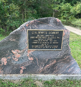
James Herbert White and Cairn (1875-1957).

James White played an important role at St. Williams and Turkey Point Stations. He served as Superintendent for about two years when Frank Newman was at war. He was responsible for the planting design and experiments at Turkey Point. He brought his students annually to plant trees and see example of practical silviculture. He was advisor to both Zavitz and Frank Newman.
White was the first graduate in 1909 of the Faculty of Forestry at University of Toronto having obtained two degrees previously. On graduation he was appointed as a faculty lecturer. In 1919 he obtained his doctorate and subsequently Associate Professor and Professor. In his obituary it states, ‘It was as a university teacher that he was best known and the hundreds of students that attended his lectures will long remember him for the philosophy of forestry and of life generally that he imparted in his own forceful, colorful and kindly way. He will be remembered as an outstanding personality in whom were combined the qualities of an excellent teacher, exceptional powers of observation, love of truth and devotion to duty, and a personality that exacted respect. He will always occupy a high place in the profession by virtue of his work as a great leader and mentor of forestry in his native province during its earliest, formative, and most difficult years. He was a great organizer also and had a great capacity for work’.
When Frank Newman returned after the War he resumed as Superintendent and White was further seconded to the Provincial Forestry Branch (PFB) as Assistant Provincial Forester to Edmund Zavitz. While there he began the organization of the PFB into districts and the district system of administration today (1957) is largely his design. He retained his Forestry Branch connection acting in an advisory capacity to the Provincial Forester until 1934. In 1925 the Department of Lands and Forests published White’s “The Forest Trees of Ontario”.
In 1926 property was acquired in the blow sands in Charlotteville Township. This Turkey Point area became Forestry Station No. 2. This also became Frank Newman’s responsibility and he turned the mangement over to White. White quickly developed a reforestation program. Many areas of the Station were divided into two-acre (~0.8 ha) blocks to test various combinations of planting spacing and in combination with other species. The plots were 330 by 264 feet (~100 by 80 m) with a 16 foot (5 m) road separating plots. Major species blocks were white pine, red pine, Scot’s pine, white spruce, and larch. Newman’s crews did the layout and most of the planting. White brought his forestry students to the Station annually in the spring. The students planted or replanted some trees but mostly did measurements as well as learning other aspects of forestry and nursery management.
There were numerous failures and much replanting. Hardwoods generally did not survive. Unfortunately, the files containing results of these experiments have been lost. Over the years species such as Scot’s and jack pine were replaced with white or red pine, as trees grew normal harvest operation occurred. With the exception of red and white pine plots, there is very little evidence in the field and any there is, is hard to find.
White retired in 1946 and in 1949 a cairn was unveiled and dedicated, commemorating his early work and Station 2 was renamed “The J. H. White Forest” The location of the cairn was on the east side of the Station in what is now the Provincial Park. In 2010 the plaque was moved to Turkey Point Road immediately across the road from the Park entrance.

This 1928 map shows the location of the two acre plots as planned by J.H. White in the Turkey Point Tract. The red pine, Scot’s pine and spruce plots are identified on the map. The un-named larch plots are in the upper right and the numerous white pine plots are in the top left. ON the bottom left are nursery beds. The larger plantation blocks have the first year of planting with the species. The main part of Turkey Point Provincial Park, established in 1959, is outlined in blue. The legend is expanded to be more readable.
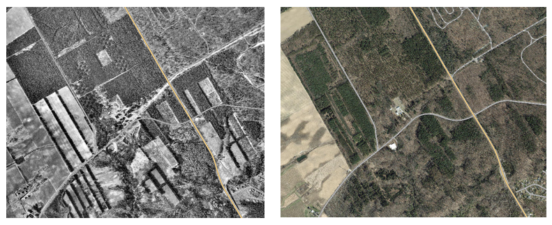
Comparison of 1964 and 2020 aerial photos. Southern part of Turkey Point Tract and the Provincial Park in the top right. Top left shows the experimental design in the red pine group in the 1964 photo.
Bottom left of 1964 shows recently planted land for experiment conducted by Lands and Forests scientists. At the very left bottom are the narrow plots of the picetum.
Turkey Point Road is the orange line on both photos. Front Road runs diagonally through the 1964 photo. When the Park was established Front Road was moved south from its original route. The park entrance is the original Front Road.
Turkey Point Picetum - Dave Morris, MNRF
The Picetum was established in the 1960s (not sure the planting date), and represents a significant contribution to the conservation of unique gene pools of Picea. This unique collection includes representatives from across North America and around the world, including high and low elevation specimens as well as spruces from northern and southern climes. Some of the species present no longer have wild populations. The Turkey Point Piceta, is one of six Picetum established along a latitudinal array across Ontario (from Turkey point to Kenora), as well as 4 additional installations worldwide. This important assemblage of genetic material, and the associated breeding program conducted by Dr. Gordon, has important implications in the face of an ever-changing climate, and the potential for investigating disease/insect resistance.
In total there are 72 different collections, established in 9 – tree plots, with five replicate (blocks) plantings. These include 23 individual species, a number of provenances (collections along latitudinal arrays) of key species, and some naturally occurring hybrids. North American species include: P. rubens (4), P. mariana (6), P. glauca (13), P. sitchensis (9), P. engelmannii, P. pungens, P. breweriana, from Mexico: P. Mexicana and P. chinuahauna (unfortunately, we lost all of these through suppression by faster growing species). Other species represented from other parts of the world include: P. abies (4: from Austria, Sweden, Germany), Russia: P. obovata, P. omorika, P. schrenkiana, Turkey: P. orientalis, China: P. schrenkiana, P. asperata, P. meyeri, P. wilsonii, P. lutzii, P. likiangensis, and from Japan: P. jezoensis, P. koyamai, P. glehnii, P. polita.
The adjacent south and north fields, include unique crosses that Dr. Gordon has been able to cultivate.
Beyond the breeding program, and assessment of the hybrids – focus has been on productivity potential (genetic gains), but are not limited to those, ongoing work at the Turkey Point and other piceta include: 1. species growth and foliar nutritional response when grown in a common garden plot, and how these relationships change under different climate regimes (utilizing the latitudinal provenances, and more northern installations), 2. long-term soil chemical changes resulting from intensive forest management (conversion of natural forests to intensively-managed, conifer plantations – focus has been on the accelerated loss of soil base cations, with particular emphasis on Ca decline), 3. species-specific changes in soil meso-fauna (plot size is somewhat problematic) – implications into changes in soil processes related to nutrient cycling; 4. species-specific changes in throughfall and stemflow chemical signatures – again, implications with respect to changes in nutrient cycling patterns and processes,…
The picetum was only a small part of the research program started in the late 1950’s and carried on through the 1970’s. There were collections of various hard pines (jack, red, Austrian, Scot’s, ponderosa); provenance tests (a variety of seed sources (or provenances) planted at several test sites across the range of a species); and progeny tests which evaluate the breeding potentialities of parent plants. There were a number of testing hybrids of various species.
Variable Density Thinning Trial – Ken Elliott, R.P.F.
What: Use variable retention harvest to restore conifer plantations to native forest types and enhance resilience to climate change
variable density thinning (VDT) = variable density harvesting (VRH)
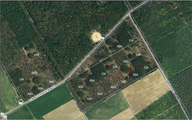
Figure 1. Post-harvest – showing treatment blocks – red triangles denote location of environmental monitoring stations. St. Williams Conservation Reserve Turkey PT. ON.
33D = 33% basal area retention in a uniform dispersed pattern,
55D = 55% basal area retention in a uniform dispersed pattern,
33A = 33% retention in an aggregate pattern (4 aggregate retained patches)
55A = 55% retention in an aggregate pattern (4 aggregate retained patches)
CN = unharvested control
+ 4 to 6 stubs per block (80 total) and retention of snags and stick nest trees
Who:
- Williams Conservation Reserve Community Council (SWCRCC) – permission/oversight – Lead – Audrey Heagy
- MNRF - concept, design, implementation - Bill Parker – Research Scientist, Ken Elliott – Carolinian Forest Science Specialist, Steve Williams – Aylmer District Forester
- Collaborative Researchers:
- Altaf Arain (McMaster U.) + graduate students and other contacts:
- Growth, survival, and water use of red pine canopy trees
- Soil respiration and C exchange
- Bill Parker/Dr. Eric Searle (FRMS-MNRF):
- Stand structure and understory light
- Growth and survival of advance tree regeneration
- Stephen Murphy (U. Waterloo):
- Soil fauna, soil fungi, and nutrient cycling
- Shelly Hunt (U. Guelph):
- Understory vegetation dynamics
- Doug Tozer (Birds Canada):
- VRH effects on bird populations
- Erica Nol (Trent U.)
- Habitat value of stub trees
- Altaf Arain (McMaster U.) + graduate students and other contacts:
Why:
Provide conditions to encourage transition to mixed natural Carolinian forest with large legacy red pine trees in clumps and as individual super canopy trees overtopping the younger mixed forest. This is in contrast to uniform traditional thinning. The patch mosaic created by the combination of skips (no tree removal), gaps (removal of all trees) and single-tree, even-aged thinning to two different densities is expected to increase species diversity and ecological complexity while advancing the natural succession and restoration of these plantations to native forest types. Since biodiversity is positively related to the capacity of forest vegetation to resist and recover from environmental stresses, it is expected that VRH will improve the capacity of the stand to weather the increasing frequency and magnitude of stresses associated with future climate change.
When: 1931 - trees planted, 1960 - thinned 4th row, possibly another thinning
2011 - discussions commence on this trial, 2014 - variable retention harvest
2015 to present - research and data collection
Results:
- Tree growth, carbon increment, and evapotranspiration - increased by dispersed retention
- Total carbon increment (excluding products removed) - greatest at highest retention level
- The greater the harvest intensity (33% retention) the more the understory vegetation grew and the more evapotranspiration that occurred in the understory
- Canopy transpiration contributed 83% of evapotranspiration in the CN plot and 58%, 55%, 30% and 23% in the 55D, 55A, 33A and 33D treatments, respectively
- VRH treatments increased the water use efficiency of the canopy but not the understory
- More to come
Bodo AV, Parker WC, Elliott KA and Arain MA. 2022. Below canopy evapotranspiration in four different variable retention harvesting treatments in a red pine plantation forest. Hydrological Processes. 2023;37:e14789, https://doi.org/10.1002/hyp.14789
Zugic JI, Pisaric MFJ, McKenzie SM, Parker WC, Elliott KA and Arain MA. 2021. The Impact of Variable Retention Harvesting on Growth and Carbon Sequestration of a Red Pine (Pinus resinosa Ait.) Plantation Forest in Southern Ontario, Canada. Front. For. Glob. Change 4:725890. doi: 10.3389/ffgc.2021.725890
Turkey Point Flux Station – Altaf Arain, McMaster University
The McMaster Centre for Climate Change, Hamilton, is involved in measuring carbon, water and energy fluxes and associated metrological and physiological variables in planted or managed conifer and deciduous forests in southern Ontario. The aim of this project is to determine how much carbon dioxide is being removed from the atmosphere by planted coniferous and deciduous forests as they grow in temperate climate of the southern Ontario and how these forests may be affected by the climate change and extreme weather events. This research would help to develop management strategies for sustainable development and use of eastern Canada’s forests and to assess the economic potentials and vulnerability of forests to climate change at local and regional scales. It would also help to develop and test next-generation of ecosystem and hydrologic models.
Heat and drought impact on carbon exchange in an age‑sequence of temperate pine forests
M. Altaf Arain1* , Bing Xu1,2, Jason J. Brodeur1, Myroslava Khomik1,3, Matthias Peichl1,4, Eric Beamesderfer5, Natalia Restrepo‑Couple1,6 and Robin Thorne1,7
Abstract
Background: Most North American temperate forests are plantation or regrowth forests, which are actively managed. These forests are in different stages of their growth cycles and their ability to sequester atmospheric carbon is affected by extreme weather events. In this study, the impact of heat and drought events on carbon sequestration in an age-sequence (80, 45, and 17 years as of 2019) of eastern white pine (Pinus strobus L.) forests in southern Ontario, Canada was examined using eddy covariance flux measurements from 2003 to 2019.
Results: Over the 17-year study period, the mean annual values of net ecosystem productivity (NEP) were 180 ± 96, 538 ± 177 and 64 ± 165 g C m– 2 yr– 1 in the 80-, 45- and 17-year-old stands, respectively, with the highest annual carbon sequestration rate observed in the 45-year-old stand. We found that air temperature (Ta) was the dominant control on NEP in all three different-aged stands and drought, which was a limiting factor for both gross ecosystem productivity (GEP) and ecosystems respiration (RE), had a smaller impact on NEP. However, the simultaneous occurrence of heat and drought events during the early growing seasons or over the consecutive years had a significant negative impact on annual NEP in all three forests. We observed a similar trend of NEP decline in all three stands over three consecutive years that experienced extreme weather events, with 2016 being a hot and dry, 2017 being a dry, and 2018 being a hot year. The youngest stand became a net source of carbon for all three of these years and the oldest stand became a small source of carbon for the first time in 2018 since observations started in 2003. However, in 2019, all three stands reverted to annual net carbon sinks.
Conclusions: Our study results indicate that the timing, frequency and concurrent or consecutive occurrence of extreme weather events may have significant implications for carbon sequestration in temperate conifer forests in Eastern North America. This study is one of few globally available to provide long-term observational data on carbon exchanges in different-aged temperate plantation forests. It highlights interannual variability in carbon fluxes and enhances our understanding of the responses of these forest ecosystems to extreme weather events. Study results will help in developing climate resilient and sustainable forestry practices to offset atmospheric greenhouse gas emissions and improving simulation of carbon exchange processes in terrestrial ecosystem models.
Keywords: Carbon fluxes, Net ecosystem productivity, Ecosystem respiration, Extreme weather events, Drought, Temperate forest, White pine, Eddy covariance, Variable Spacing Trial
Bibliography
Bacher, John 2011. Two Billion Trees and Counting: The legacy of Edmund Zavitz, Dundurn Natural Heritage, Toronto, ON
Barrett, Harry B. 2008 They Had a Dream: A History of the St. Williams Forestry Station. Port Rowan, ON. South Walsingham Heritage Association
Department of Lands, Forests and Mines Annual Report. 1913
James Herbert White obituary. 1957. The Forestry Chronicle Vol. 33 • No. 4 • pp. 387 - 388
Station Report 1928. Norfolk County Archives. Box ARV S173 B08.
Station Report 1929. Norfolk County Archives. Box ARV S173 B08
Dolf Wynia 2021. A Trail of White Pine across the Ocean from Germany to Ontario. Forestory, Vol. 12:1
Zavitz, C. Harold. 1963. A history of the Lake Erie Forest District. Dept. of Lands and Forests.
Zavitz, E. J. 1908. Report on the Reforestation of Waste Lands in Southern Ontario. Published By the Ontario Department of Agriculture, Toronto